


site search
online catalog
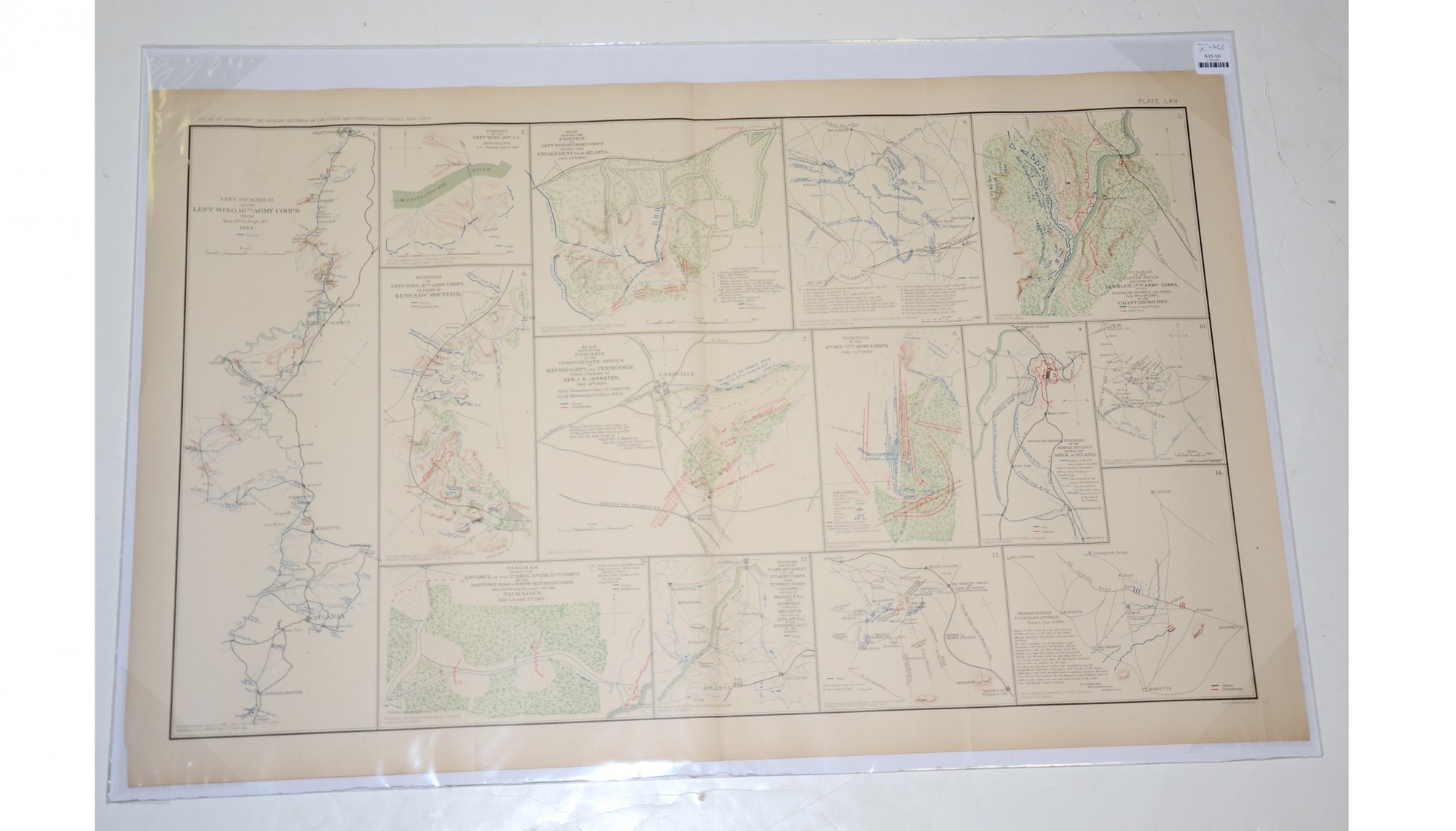
MAPS OF 16TH AND 17TH ARMY CORPS OPERATIONS IN MISSISSIPPI, TENNESSEE, GEORGIA IN 1864
$35.00 SOLD
Quantity Available: None
Item Code: L15163
These pages area from an official government atlas with fourteen maps of the operations of the 16th and 17th Army Corps in Mississippi and Tennessee, and the Siege of Atlanta. The Baylor University Libraries Digital Collection description reads:
“Map showing the position of the Confederate Armies of the Mississippi and Tennessee -- Diagram showing the advance of the 3d Brig. 4th. Div. 17th Corps on the Sandtown Road to Widow Mitchell's Farm and from there East to the Nickajack, July 3, 4 and 5th, 1864 -- Map showing the position of left wing 16th Army Corps during the engagement near Atlanta. -- Position of left wing 16th Army Corps in front of Kennesaw Mountain -- Positions of the 4th Div. 17th Army Corps, July 22d, 1864 -- Atlanta campaign diagram accompanying diary of Lieut. Col. J.S. Fullerton -- Diagram of the General Situation during the Siege of Atlanta -- Line of March of the left wing 16th Army Corps -- Diagram of the Battle-field occupied by Gen. Blair, 17th Army Corps -- Position of the left wing 16th A.C. -- Map of area surrounding Powder Springs, Georgia -- Headquarters 2d Cavalry Division, Tyson's, June 12, 1864 -- Map of area surrounding Mt. Olivet Church -- Diagram showing the flank movement of the 17th Army Corps from Turner's Ferry (July 16, 1864) by way of Marietta and Roswell to south of Decatur and east of Atlanta, to the extreme left of the Army -- Created by Morris”
The map is labeled Plate LXII, from the Atlas to Accompany the Official Records of the Union and Confederate Armies from 1861 to 1865, originally published in 1891. The Atlas to Accompany the Official Records of the Union and Confederate Armies (also referred to as the War of the Rebellion Atlas) was published as a companion piece to the Official Records of the American Civil War. It contains maps and other images derived from materials generated by both Union and Confederate military personnel during the American Civil War.
The map measures 29.25” long by 18.5” wide. In good condition.
UPS SHIPPING: East of the Mississippi, $15.00; West of the Mississippi, $20.00. Insurance $5.00 additional.
~~~~~~~~~~~~~~~~~~~~~~~~~~~~~~~~~~~
THIS ITEM, AS WITH ALL OTHER ITEMS AVAILABLE ON OUR WEB SITE,
MAY BE PURCHASED THROUGH OUR LAYAWAY PROGRAM.
FOR OUR POLICIES AND TERMS,
CLICK ON ‘CONTACT US’ AT THE TOP OF ANY PAGE ON THE SITE,
THEN ON ‘LAYAWAY POLICY’.
THANK YOU!
Inquire About MAPS OF 16TH AND 17TH ARMY CORPS OPERATIONS IN MISSISSIPPI, TENNESSEE, GEORGIA IN 1864
For inquiries, please email us at [email protected]
Most Popular
Historical Firearms Stolen From The National Civil War Museum In Harrisburg, Pa »
Theft From Gravesite Of Gen. John Reynolds »
Cavalry Carbine Sling Swivel »
Fine Condition Brass Infantry Bugle Insignia »
featured item
MISSOURI CONFEDERATE FROCK COAT, SASH, CS SWORD BELT, AND HOLSTER, OF MAJOR WILLIAM F. HAINES, WITH FAMILY ARCHIVE OF PHOTOS & PAPERS: SHILOH, VICKSBURG, AND NEGOTIATIONS WITH SHERMAN FOR SURRENDER OF GEN. L.S. BAKER’S COMMAND IN APRIL 1865
This beautiful, identified Confederate major’s coat, sash, sword belt, sash, and holster, once in the Texas Civil War Museum, comes with two brown ink notes that were pinned to it, one reading: “Major W. F. Haines / Bowens Staff / Confederate… (1179-277). Learn More »