


site search
online catalog
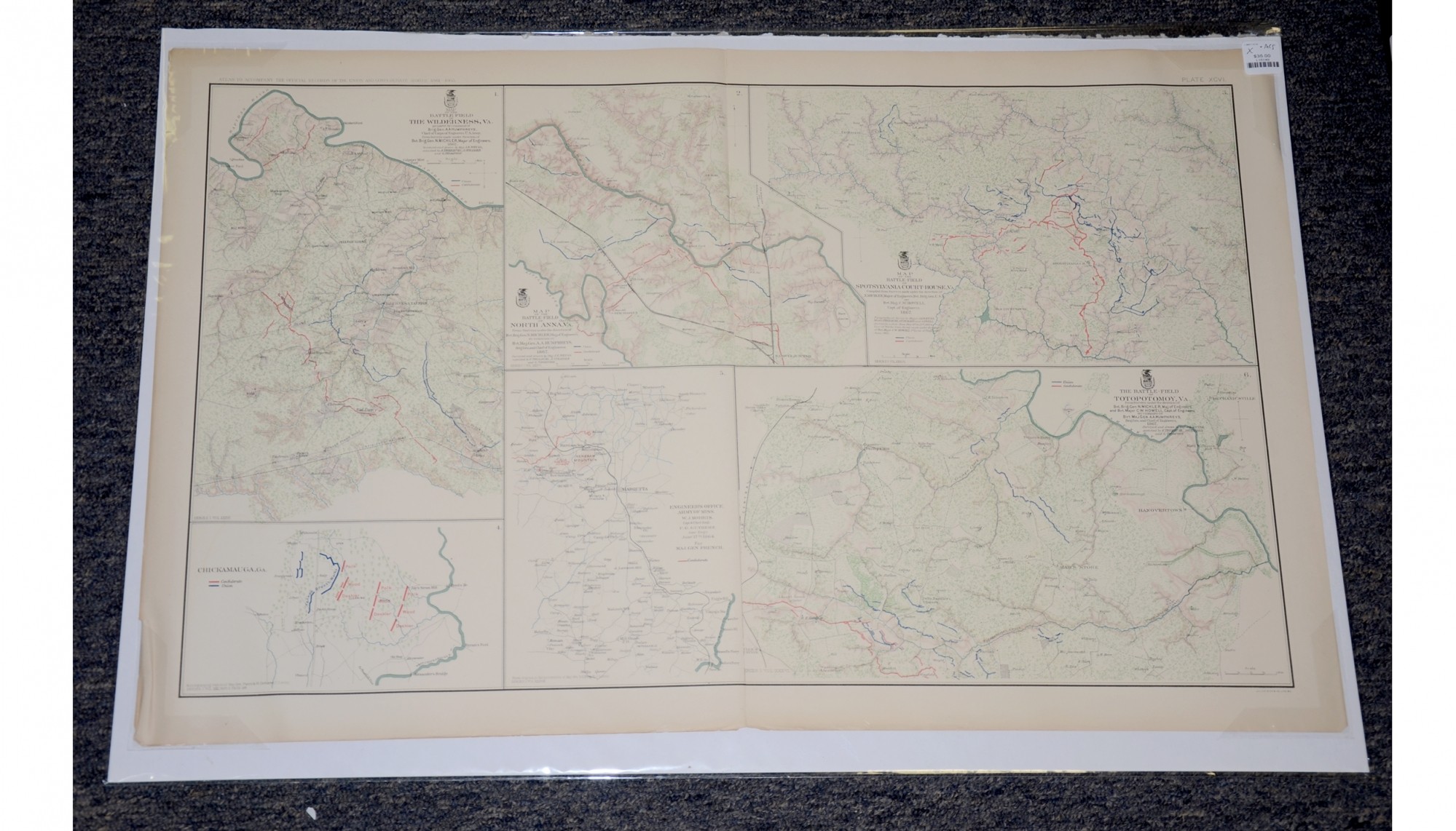
MAPS OF WILDERNESS, VA., CHICKAMAUGA, GA., KENNESAW MOUNTAIN, GA. AND THE BATTLEFIELDS OF THE SPOTSYLVANIA COURT HOUSE, NORTH ANNA, AND TOTOPOTOMOY FROM ATLAS OF OFFICIAL RECORDS
$35.00 SOLD
Quantity Available: None
Item Code: L15149


These pages from an official government atlas feature maps of Wilderness, Va., Chickamauga, Ga., Kennesaw Mountain, Ga. and the battlefields of the Spotsylvania Court House, North Anna, and Totopotomoy. The Baylor University description reads:
Map of the Battle-field of The Wilderness, Va. Prepared by command of Brig. Gen. A.A. Humphreys, Chief of Corps of Engineers U.S. Army, From Surveys made under direction of Bvt. Brig. Gen. N. Michler, Major of Engineers, 1867 -- [Marietta, Georgia area, from] Engineer's Office, Army of Miss. W.J. Morris, Capt. & Chief Engr. F.G. Gutherz, Asst. Eng'r. June 17th, 1864. For Maj. Gen. French -- The Battle-field of Totopotomoy, Va. From Surveys under the direction of Bvt. Brig. Gen. N. Michler, Maj. of Engineers and Bvt. Major C.W. Howell, Capt. of Engineers by command of Bvt. Maj. Gen. A.A. Humphreys, Brig. Gen. and Chief of Engineers, 1867 -- Chickamauga, Ga. -- Map of the Battle-field of North Anna, Va. From Surveys under the direction of Bvt. Brig. Gen. N. Michler, Maj. of Engineers by command of Bvt. Maj. Gen. A.A. Humphreys, Brig. Gen. and Chief of Engineers. 1867 -- Map of the Battle-field of Spotsylvania Court-House, Va. Compiled from Surveys made under the direction of N. Michler, Major of Engineers, Bvt. Brig. Gen. U.S.A. and Bvt. Maj. C.W. Howell, Capt. of Engineers. 1867 -- Created by Michler, Weyss, Howell, Theilkuhl, Burchard, Oswell, Strasser, Thompson
The map is labeled Plate XCVI, from the Atlas to Accompany the Official Records of the Union and Confederate Armies from 1861 to 1865, originally published in 1891. The Atlas to Accompany the Official Records of the Union and Confederate Armies (also referred to as the War of the Rebellion Atlas) was published as a companion piece to the Official Records of the American Civil War. It contains maps and other images derived from materials generated by both Union and Confederate military personnel during the American Civil War.
The map measures 29.25” long by 18.5” wide. In good condition with slight tears on the fold.
UPS SHIPPING: East of the Mississippi, $15.00; West of the Mississippi, $20.00. Insurance $5.00 additional.
~~~~~~~~~~~~~~~~~~~~~~~~~~~~~~~~~~~
THIS ITEM, AS WITH ALL OTHER ITEMS AVAILABLE ON OUR WEB SITE,
MAY BE PURCHASED THROUGH OUR LAYAWAY PROGRAM.
FOR OUR POLICIES AND TERMS,
CLICK ON ‘CONTACT US’ AT THE TOP OF ANY PAGE ON THE SITE,
THEN ON ‘LAYAWAY POLICY’.
THANK YOU!
Inquire About MAPS OF WILDERNESS, VA., CHICKAMAUGA, GA., KENNESAW MOUNTAIN, GA. AND THE BATTLEFIELDS OF THE SPOTSYLVANIA COURT HOUSE, NORTH ANNA, AND TOTOPOTOMOY FROM ATLAS OF OFFICIAL RECORDS
For inquiries, please email us at [email protected]
Most Popular
Historical Firearms Stolen From The National Civil War Museum In Harrisburg, Pa »
Theft From Gravesite Of Gen. John Reynolds »
Cavalry Carbine Sling Swivel »
Fine Condition Brass Infantry Bugle Insignia »
featured item
VERY FINE VETERAN RESERVE CORPS JACKET ATTRIBUTED TO 9TH MASSACHUSETTS SOLDIER WOUNDED AT SPOTSYLVANIA AND LATER SERVED IN COMPANY H, 13TH VETERAN RESERVE CORPS
Very fine original Veteran Reserve Corps jacket and Pattern 1858 smooth-side canteen with a verbal ID to Private Patrick Barry formerly of Company E, 9th Massachusetts Infantry wounded at Spotsylvania on May 12, 1864. The jacket is in very fine… (1179-177). Learn More »