


site search
online catalog
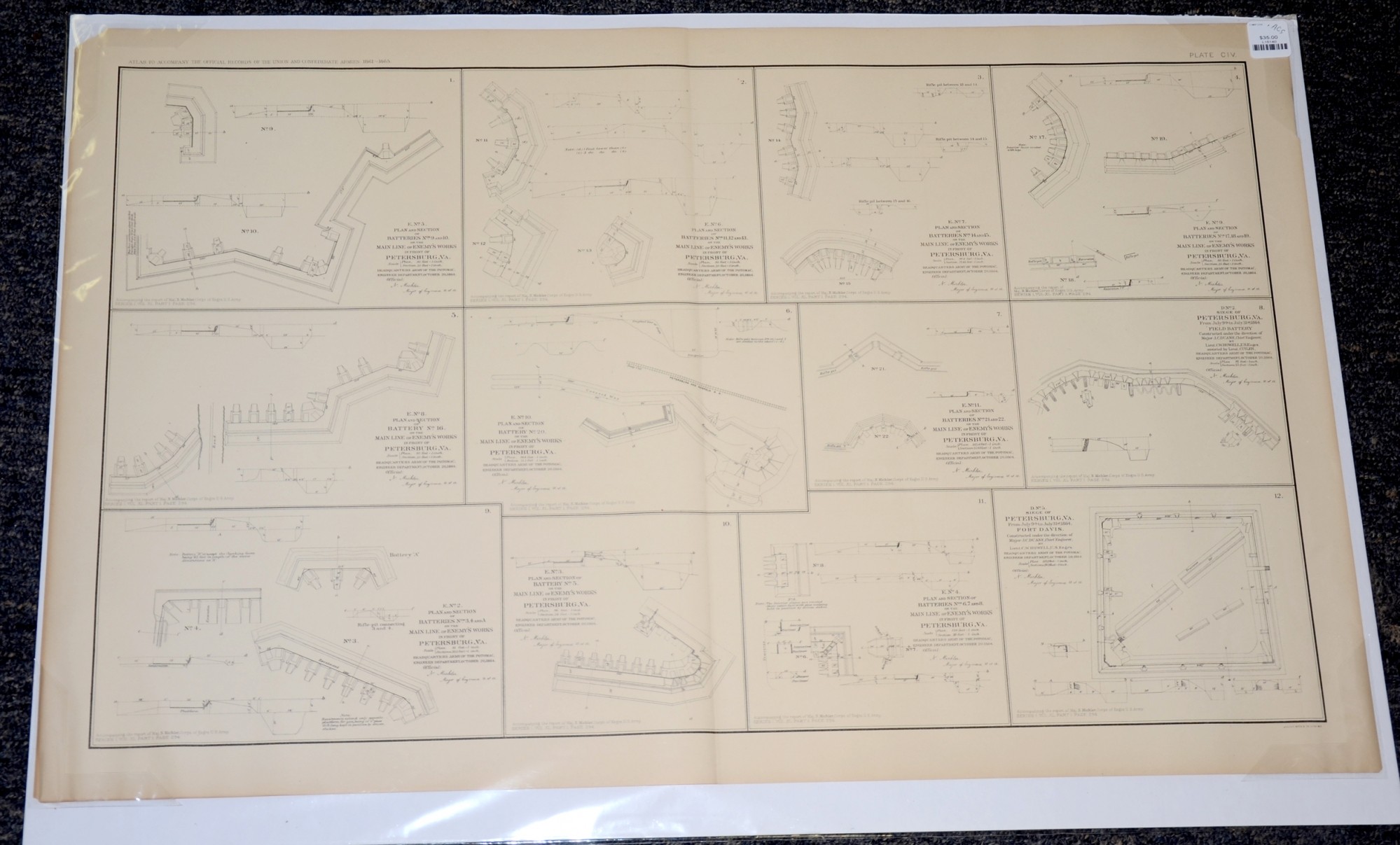
PLANS AND SECTION OF BATTERIES IN PETERSBURG VA FROM ATLAS OF OFFICIAL RECORDS
$35.00 SOLD
Quantity Available: None
Item Code: L15140

These pages are from an official government atlas include 12 drawings of plan and sections of batteries at Petersburg, Va. The description on Baylor University’s Digital Libray reads:
“Plan and Section of Battery No. 5 on the Main Line of Enemy's Works in front of Petersburg, Va. -- Plan and Section of Batteries Nos. 3, 4 and A on the Main Line of Enemy's Works in front of Petersburg, Va. -- Plan and Section of Batteries Nos. 14 and 15 on the Main Line of Enemy's Works in front of Petersburg, Va. -- Siege of Petersburg, Va. From July 9th to July 31st, 1864. Fort Davis. Constructed under the direction of Major J.C. Duane, Chief Engineer, by Lieut. C.W. Howell, U.S. Engr's. Headquarters Army of the Potomac, Engineer Department, October 20, 1864 -- Plan and Section of Battery No. 20 on the Main Line of Enemy's Works in front of Petersburg, Va. -- Plan and Section of Batteries Nos. 17, 18 and 19 on the Main Line of Enemy's Works in front of Petersburg, Va. -- Plan and Section of Batteries Nos. 11, 12 and 13 on the Main Line of Enemy's Works in front of Petersburg, Va. -- Siege of Petersburg, Va. From July 9th to July 31st, 1864. Field Battery Constructed under the direction of Maj. J.C. Duane, Chief Engineer, by Lieut. C.W. Howell, U.S. Engrs. assisted by Lieut. Cuyler, Headquarters Army of the Potomac, Engineer Department, October 20, 1864 -- Plan and Section of Batteries Nos. 21 and 22 on the Main Line of Enemy's Works in front of Petersburg, Va. -- Plan and Section of Batteries Nos. 9 and 10 on the Main Line of Enemy's Works in front of Petersburg, Va. -- Plan and Section of Batteries Nos. 6, 7 and 8 on the Main Line of Enemy's Works in front of Petersburg, Va. -- Plan and Section of Battery No. 16 on the Main Line of Enemy's Works in front of Petersburg, Va.”
The map is labeled Plate CIV, from the Atlas to Accompany the Official Records of the Union and Confederate Armies from 1861 to 1865, originally published in 1891. The Atlas to Accompany the Official Records of the Union and Confederate Armies (also referred to as the War of the Rebellion Atlas) was published as a companion piece to the Official Records of the American Civil War. It contains maps and other images derived from materials generated by both Union and Confederate military personnel during the American Civil War.
The map measures 29.25” long by 18.5” wide. In good condition with small chips in the top corners.
UPS SHIPPING: East of the Mississippi, $15.00; West of the Mississippi, $20.00. Insurance $5.00 additional.
~~~~~~~~~~~~~~~~~~~~~~~~~~~~~~~~~~~
THIS ITEM, AS WITH ALL OTHER ITEMS AVAILABLE ON OUR WEB SITE,
MAY BE PURCHASED THROUGH OUR LAYAWAY PROGRAM.
FOR OUR POLICIES AND TERMS,
CLICK ON ‘CONTACT US’ AT THE TOP OF ANY PAGE ON THE SITE,
THEN ON ‘LAYAWAY POLICY’.
THANK YOU!
Inquire About PLANS AND SECTION OF BATTERIES IN PETERSBURG VA FROM ATLAS OF OFFICIAL RECORDS
For inquiries, please email us at [email protected]
Most Popular
Historical Firearms Stolen From The National Civil War Museum In Harrisburg, Pa »
Theft From Gravesite Of Gen. John Reynolds »
Cavalry Carbine Sling Swivel »
Fine Condition Brass Infantry Bugle Insignia »
featured item
US MARINE CORPS OFFICER’S ENGLISH MADE MAMALUKE WITH IVORY GRIP
Manufactured: England Maker: Unmarked Year: C1820-25 Model: Mamaluke Size: 35.8 inch blade, 1.21 wide Condition: Excellent+ Tri-color blade - blue, gold and "white" of flat design. Ship's Mast, American Eagle, Standing Indian figure and… (870-76). Learn More »