


site search
online catalog
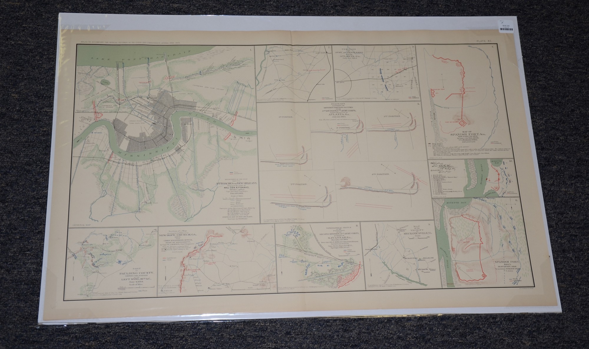
1864 MAPS OF ATLANTA, SPANISH FORT, AL, NEW HOPE CHURCH, MECHANICSVILLE, VA FROM ATLAS OF OFFICIAL RECORDS
$35.00 SOLD
Quantity Available: None
Item Code: L15172

These pages from an official government atlas feature maps of locations in Georgia and Alabama. The Baylor University Libraries Digital Collection description reads:
Map of Spanish Fort, Ala., made during the siege by Lieut. J.A. Chalaron, 5th Co., Washington Artillery -- Ross' Camp near East Point, GA -- Part of Paulding County, showing the position of the Left Wing, 16th A.C., June 4th, 1864 -- Spanish Fort, 1865. Drawn during siege by Assistant Surgeon Bull, C.S. Army -- Department of the Gulf. Map No. 5. Approaches to New Orleans, Prepared by order of Maj. Gen. N.P. Banks, Henry L. Abbot, Capt. and Chief Top. Engrs. Feb. 14th, 1863 -- Map of Spanish Fort, Alabama area dated April 4, 1865 -- Section of a Map showing the Lines near New Hope Church, Ga., 1864. From Chief Engineer's Office, Army of Mississippi, by Capt. W.J. Morris, Chief Engineer -- Map of the Vicinity of Mechanicsville, Va. -- Topographical sketch of the Position of the Second Division, 14th Army Corps, in front of Savannah, Ga., December 11th, 1864. Brig. Gen. Jas. D. Morgan, Commanding Division. Surveyed and drawn by Chas. Petri, Major, 16th Ill. V.I., Top'. Engr. 2d. Div. 14th A.C. -- Diagrams illustrating the different positions occupied by the 4th Division, 17th Army Corps, during the battle of Atlanta, Ga., July 22, 1864 -- Position of Army of Tennessee near Atlanta, Ga., July 22, 1864 -- Created by McPherson, Petri, Morris, Johnson, Chalaron, Bull, Abbot, Oltsman, Robbins, Hosmer, Deutsch, Wilder.
The map is labeled Plate XC, from the Atlas to Accompany the Official Records of the Union and Confederate Armies from 1861 to 1865, originally published in 1891. The Atlas to Accompany the Official Records of the Union and Confederate Armies (also referred to as the War of the Rebellion Atlas) was published as a companion piece to the Official Records of the American Civil War. It contains maps and other images derived from materials generated by both Union and Confederate military personnel during the American Civil War.
The map measures 29.25” long by 18.5” wide. In good condition.
UPS SHIPPING: East of the Mississippi, $15.00; West of the Mississippi, $20.00. Insurance $5.00 additional.
~~~~~~~~~~~~~~~~~~~~~~~~~~~~~~~~~~~
THIS ITEM, AS WITH ALL OTHER ITEMS AVAILABLE ON OUR WEB SITE,
MAY BE PURCHASED THROUGH OUR LAYAWAY PROGRAM.
FOR OUR POLICIES AND TERMS,
CLICK ON ‘CONTACT US’ AT THE TOP OF ANY PAGE ON THE SITE,
THEN ON ‘LAYAWAY POLICY’.
THANK YOU!
Inquire About 1864 MAPS OF ATLANTA, SPANISH FORT, AL, NEW HOPE CHURCH, MECHANICSVILLE, VA FROM ATLAS OF OFFICIAL RECORDS
For inquiries, please email us at [email protected]
Most Popular
Historical Firearms Stolen From The National Civil War Museum In Harrisburg, Pa »
Theft From Gravesite Of Gen. John Reynolds »
Cavalry Carbine Sling Swivel »
Fine Condition Brass Infantry Bugle Insignia »
featured item
VERY RARE US MODEL 1840 AMES CAVALRY OFFICER’S SWORD WITH QUILLBACK SOLINGEN BLADE
Very rare Ames with gold washed, quillback, Damascus blade from Solingen. Manufactured: Springfield, MA / Solingen Maker: N.P.Ames Year: C1840s Model: M1840 Size: 33 5/8 inch blade length, 1.18 wide Condition: Excellent+ This is obviously a product… (870-238). Learn More »