


site search
online catalog
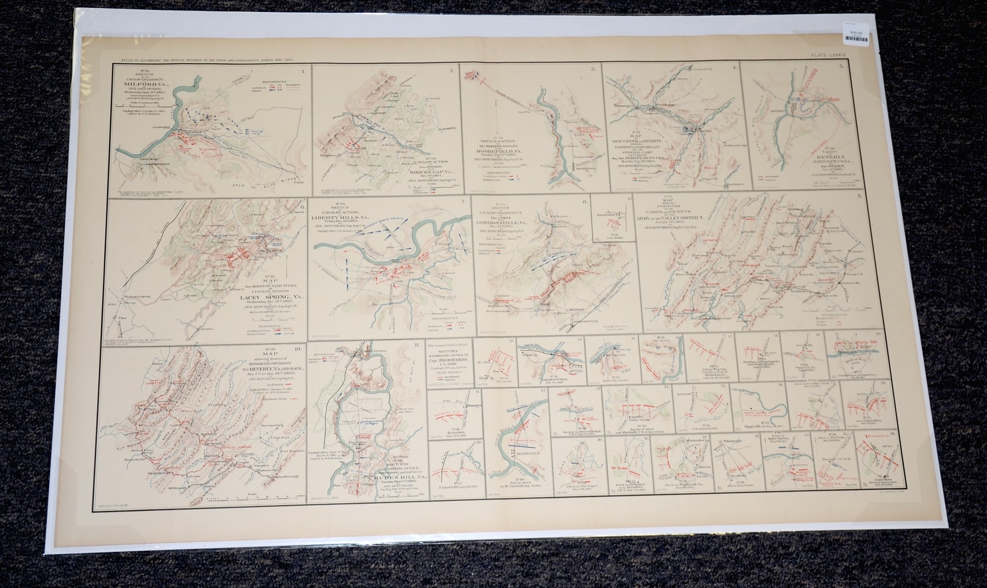
MAPS OF VARIOUS VIRGINIA BATTLEFIELDS (1864-65) FROM ATLAS OF OFFICIAL RECORDS
$35.00 SOLD
Quantity Available: None
Item Code: L15128

This page from an official government atlas feature maps of locations in Georgia and Alabama. The Baylor University Libraries Digital Collection description reads:
Map showing Positions of the Camps and Pickets of the Army of the Valley District, January 31st, 1865 -- Sketch of Cavalry Action, at Liberty Mills, Va., Friday, Dec. 23d, 1864 -- Capture of Beverly, Randolph Co., Va., by Gen. Rosser, Jan. 11th, 1865 -- Sketch of Cavalry Engagement of Gen. Lomax near Gordonsville, Va., Dec. 24th, 1864 -- Cavalry Action of Gen. Rosser near Brock's Gap, Va., Oct. 6th, 1864 -- Map of New Creek and Vicinity, showing Position of Fort Kelley and the Federal Camp captured by Maj. Gen. Rosser's Cav. Div. A.N.V., Monday, Nov. 28th, 1864 -- Sketch of the Cavalry Engagement at Milford, Va., of Fitz Lee's Division, Wednesday, Sept. 21st, 1864 -- Sketch of Action of Gen. Rosser's Cavalry, near Moorefield, Va., Sunday, Nov. 27th, 1864 -- Map showing Routes of Rosser's Division to Beverly, Va., and back, Jan. 7th to Jan. 18th, 1865 -- Map of Gen. Rosser's Night Attack on Custer's Division at Lacey Spring, Va., Wednesday, Dec. 21st, 1864 -- Sketches Accompanying Journal of Capt. Jed. Hotchkiss, C.S. Army, Top. Engr. 2d. Corps, A. of N.Va. (Valley District) -- Sketch of Gen. Rosser's Attack on Federal Cavalry guarding Prisoners at Rude's Hill, Va., Tuesday, March 7th, 1865 -- Created by Hotchkiss.
The map is labeled Plate LXXXIV, from the Atlas to Accompany the Official Records of the Union and Confederate Armies from 1861 to 1865, originally published in 1891. The Atlas to Accompany the Official Records of the Union and Confederate Armies (also referred to as the War of the Rebellion Atlas) was published as a companion piece to the Official Records of the American Civil War. It contains maps and other images derived from materials generated by both Union and Confederate military personnel during the American Civil War.
The map measures 29.25” long by 18.5” wide. In good condition. [as]
UPS SHIPPING: East of the Mississippi, $15.00; West of the Mississippi, $20.00. Insurance $5.00 additional.
~~~~~~~~~~~~~~~~~~~~~~~~~~~~~~~~~~~
THIS ITEM, AS WITH ALL OTHER ITEMS AVAILABLE ON OUR WEB SITE,
MAY BE PURCHASED THROUGH OUR LAYAWAY PROGRAM.
FOR OUR POLICIES AND TERMS,
CLICK ON ‘CONTACT US’ AT THE TOP OF ANY PAGE ON THE SITE,
THEN ON ‘LAYAWAY POLICY’.
THANK YOU!
Inquire About MAPS OF VARIOUS VIRGINIA BATTLEFIELDS (1864-65) FROM ATLAS OF OFFICIAL RECORDS
For inquiries, please email us at [email protected]
Most Popular
Historical Firearms Stolen From The National Civil War Museum In Harrisburg, Pa »
Theft From Gravesite Of Gen. John Reynolds »
Cavalry Carbine Sling Swivel »
Fine Condition Brass Infantry Bugle Insignia »
featured item
TWO PEN AND INK DRAWINGS BY ALFRED WAUD / HORATIO WAIT OF BLOCKADING SCENES OFF MOBILE 1863
Working as a special artist for Harpers Weekly from late 1861 through 1865, Alfred R. Waud (1828-1891) is one of the best-known Civil War artists. In postwar years he was connected with Century Magazine, which published numerous accounts of the Civil… (557-12). Learn More »