


site search
online catalog
COLORED TOPOGRAPHICAL MAP - “ANTIETAM SHARPSBURG AND VICINITY”

$275.00 SOLD
Quantity Available: None
Item Code: 1189-48
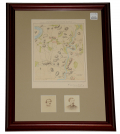
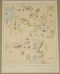

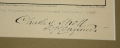
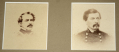
Includes small carte de visite images of Generals Robert E. Lee and George McClellan. Map Published by Virtue Thorston & Co., New York., 1864. “From an actual survey done by an Engineer Officer on General Doubleday’s staff.” “Charles Sholl / Topgl Engr.”
Framed in cherry wood, 14” x 20, w/black paper backing and hang wire. The map –7” x 9.5—is matted in beige, w/ Doubleday and McClellan Carte de visite images—1.875” x 2.25—placed below.
Colored map is in mint condition and highly attractive. Beautifully framed. Superb Antietam collectible. [jp] [ph:L]
~~~~~~~~~~~~~~~~~~~~~~~~~~~~~~~~~~~
THIS ITEM, AS WITH ALL OTHER ITEMS AVAILABLE ON OUR WEB SITE,
MAY BE PURCHASED THROUGH OUR LAYAWAY PROGRAM.
CLICK HERE FOR OUR POLICIES AND TERMS.
THANK YOU!
Inquire About COLORED TOPOGRAPHICAL MAP - “ANTIETAM SHARPSBURG AND VICINITY”
For inquiries, please email us at [email protected]
Most Popular
Historical Firearms Stolen From The National Civil War Museum In Harrisburg, Pa »
Theft From Gravesite Of Gen. John Reynolds »
Cavalry Carbine Sling Swivel »
Fine Condition Brass Infantry Bugle Insignia »
featured item
RARE CONFEDERATE “THREE SQUARE” SOCKET BAYONET
This is an excavated example of a Confederate-made musket socket bayonet. Measuring 21” overall with a 2.75” socket. This was made for an early .69 caliber musket with a bayonet lug mounted on the bottom of the barrel; as the bridge is on the… (2022-459). Learn More »