


site search
online catalog
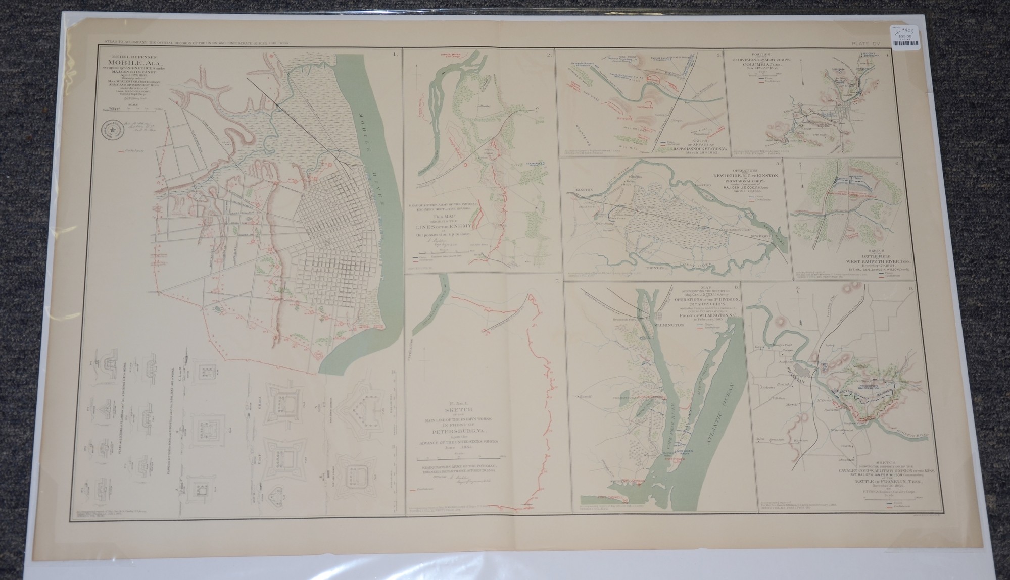
OFFICIAL RECORDS MAP OF REBEL DEFENSE IN MOBILE ALABAMA 1865 AND OTHER VARIOUS 1864 OPERATIONS IN TENNESSEE, NORTH CAROLINA, VIRGINIA
$35.00 SOLD
Quantity Available: None
Item Code: L15141
These pages from an official government atlas include nine maps including the rebel defenses at Mobile, Alabama in 1865 and Cavalry Corps operations from June – December 1864 in Virginia, North Carolina, Tennessee. The description on Baylor University’s Digital Library reads:
“Sketch showing the disposition of the Cavalry Corps, Military Division of the Miss. Bvt. Maj. James H. Wilson, Commanding, at the Battle of Franklin, Tenn., November 30, 1864 by F. Tunica, Engineer, Cavalry Corps -- Sketch of the Battle-field of West Harpeth River, Tenn., December 17th, 1864. Bvt. Maj. Gen. James H. Wilson, Comdg. -- Operations from New Berne, N.C. to Kinston, of Provisional Corps under Command of Maj. Gen. J.D. Cox, U.S. Army March 1-20, 1865 -- Sketch of Affair at Rappahannock Station, Va. March 28th, 1862 -- Sketch of the Main Line of the Enemy's Works in front of Petersburg, Va., upon the Advanced of the United States Forces June, 1864 -- Position of 3d. Division, 23d. Army Corps, at Columbia, Tenn., Nov. 24th-29th, 1864 -- Headquarters Army of the Potomac, Engineer Dept., June 18th, 1864. This Map exhibits the Lines of the Enemy in Our possession up to date. -- Rebel Defenses [of] Mobile, Ala., occupied by Union Forces under Maj. Gen. E.R.S. Canby April 12th, 1865. -- Map accompanying the report of Maj. Gen. J.D. Cox, U.S. Army of Operations of the 3d. Division, 23d. Army Corps and other Forces under his command, during the operations in Front of Wilmington, N.C., in February 1865 -- Created by Tunica, Michler, McAlester, McGregory”.
The map is labeled Plate CV, from the Atlas to Accompany the Official Records of the Union and Confederate Armies from 1861 to 1865, originally published in 1891. The Atlas to Accompany the Official Records of the Union and Confederate Armies (also referred to as the War of the Rebellion Atlas) was published as a companion piece to the Official Records of the American Civil War. It contains maps and other images derived from materials generated by both Union and Confederate military personnel during the American Civil War.
The map measures 29.25” long by 18.5” wide. In good condition with small chips in the top corners.
UPS SHIPPING: East of the Mississippi, $15.00; West of the Mississippi, $20.00. Insurance $5.00 additional.
~~~~~~~~~~~~~~~~~~~~~~~~~~~~~~~~~~~
THIS ITEM, AS WITH ALL OTHER ITEMS AVAILABLE ON OUR WEB SITE,
MAY BE PURCHASED THROUGH OUR LAYAWAY PROGRAM.
FOR OUR POLICIES AND TERMS,
CLICK ON ‘CONTACT US’ AT THE TOP OF ANY PAGE ON THE SITE,
THEN ON ‘LAYAWAY POLICY’.
THANK YOU!
Inquire About OFFICIAL RECORDS MAP OF REBEL DEFENSE IN MOBILE ALABAMA 1865 AND OTHER VARIOUS 1864 OPERATIONS IN TENNESSEE, NORTH CAROLINA, VIRGINIA
For inquiries, please email us at [email protected]
Most Popular
Historical Firearms Stolen From The National Civil War Museum In Harrisburg, Pa »
Theft From Gravesite Of Gen. John Reynolds »
Cavalry Carbine Sling Swivel »
Fine Condition Brass Infantry Bugle Insignia »
featured item
BUGLER’S SHELL JACKET IDENTIFIED TO PRIVATE WILLIAM BOPP, 2ND MISSOURI STATE MILITIA CAVALRY
Scarce Union Missouri cavalryman's jacket modified with Zouave style V-neck collar and custom-trimmed with bright yellow narrow cording at cuffs and on front, forming a semi-regulation rack pattern with looped cloverleaf ends. Seven-button front with… (591-04). Learn More »