


site search
online catalog
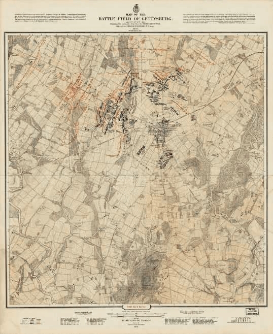
JOHN BACHELDER GETTYSBURG MAP SET - 28 MAPS COVERING THE THREE DAYS OF BATTLE PLUS EAST CAVALRY FIELD
Hover to zoom
$195.00 SOLD
Quantity Available: None
Item Code: 678-395
Of all the people who wrote about the Battle of Gettysburg in the years after the famous engagement, John B. Bachelder was by far the most important. Bachelder was the leading historian of the battle until his death. He arrived on the field soon after the battle and spent the rest of his life talking to veterans of both armies, collecting their stories, reading and interpreting battle reports, and organizing reunions so monuments could be placed in accurate positions and he could gather even more information.
In 1876, Bachelder, using the Warren Survey Map of the battlefield, published a three-map set depicting changing positions of every regiment and battery of both armies. However, this set was cluttered with too many troop positions and excluded the cavalry field.
In 1880, Bachelder contracted with the War Department to write a history of the battle. The finished product, delivered in 1886, totalled more than 2,500 pages and was accompanied by tactical maps of the battle. These maps used the Warren map as a base and provided a clear representation of troop positions during the battle.
For anyone interested in Gettysburg these are invaluable maps, the product of almost twenty years of painstaking research, by the foremost authority on the battle.
This modern, reprinted set contains the following maps:
|
July 1: (14 maps)
1: Morning position of Buford 2: 10:30 A.M. 3: 11:00 A.M. 4: 11:30 A.M. 5: 12:00 noon 6: 12:30 P.M. 7: 1:00 P.M. 8: 1:30 P.M. 9: 2:00 P.M. 10: 2:30 P.M. 11: 3:00 P.M. 12: 3:30 P.M. 13: 4:00 P.M. 14: 4:30 P.M. and later
|
July 2: (5 maps)
1: 9:00 A.M. 2: 4:00 P.M. 3: 5:00 P.M. 4: 7:00 P.M. 5: 8:00 - 9:00 P.M |
July 3: (4 maps)
1: 4:00 - 8:00 A.M. 2: 8:00 - 11:00 A.M. 3: 1:00 - 3:00 P.M. 4: 5:00 P.M. |
East Cavalry Field: (5 maps)
Base map (just terrain, no troops) 1: July 2, 6:00 - 8:00 P.M. 2: July 3, 4:00 - 11:00 A.M. 3: July 3, 2:00 P.M. 4: July 3, 2:00 - 5:00 P.M.
|
~~~~~~~~~~~~~~~~~~~~~~~~~~~~~~~~~~~
THIS ITEM, AS WITH ALL OTHER ITEMS AVAILABLE ON OUR WEB SITE,
MAY BE PURCHASED THROUGH OUR LAYAWAY PROGRAM.
FOR OUR POLICIES AND TERMS,
CLICK ON ‘CONTACT US’ AT THE TOP OF ANY PAGE ON THE SITE,
THEN ON ‘LAYAWAY POLICY’.
THANK YOU!
Inquire About JOHN BACHELDER GETTYSBURG MAP SET - 28 MAPS COVERING THE THREE DAYS OF BATTLE PLUS EAST CAVALRY FIELD
Most Popular
Historical Firearms Stolen From The National Civil War Museum In Harrisburg, Pa »
Theft From Gravesite Of Gen. John Reynolds »
Selection Of Unframed Prints By Don Troiani »
Fine Condition Brass Infantry Bugle Insignia »
featured item
VERY RARE 1834 ENGINEER AND MEDICAL STAFF SWORD BY HENRY BOKER, BELONGING TO BREVET BRIGADIER GENERAL JOHN HENDRICKSON, WHO LOST A LEG AT FREDERICKSBURG, 83rd NEW YORK VOLS (9th NYSM) AND 13th V.R.C.
New patterns of swords for the U.S. army were developed from 1832 to 1834. This elegant smallsword pattern (variously called by collectors the 1832 or 1834 pattern) was designated for officers of Engineers and Medical Staff (and Pay Department as… (870-325). Learn More »